Carburn Park
8925 Riverview Dr. S.E.
Area: 135 hectares
Carburn Park lies along the eastern shore of the Bow River and at one time was mined for gravel. The park is accessible through the community of Riverbend.
Park Features
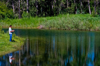
- Three man-made ponds
- Fishing and ice fishing permitted
- Canoes, dinghies, and paddle boats allowed
- Washrooms (seasonal)
- Hiking trails
- Picnic areas & shelters (call 403-268-3800 to book)
- Fire pits (firewood not provided)
- BBQ stands
- Playground area
- Cross-country skiing
- NO ice skating, swimming or motorized boat
- Off-leash area (far north portion of park)
Experience Nature in the City
Enjoy the largest ponds in the Parks system. Although ponds by definition are usually constructed bodies of water, they compliment the park's natural surroundings. Take a stroll down one stretch of narrow nature trail and enjoy a large pond on one side and the fast flowing waters of the river on the other, providing a pleasant contrast between natural and constructed environments.
Plant Life
Carburn Park offers a good example of a riverine deciduous forest and a significant shrubland community. The park's significant deciduous forest contains Balsam Poplar trees and many shrubs including American Silverberry, Saskatoon, Choke Cherry and Canada Buffaloberry.
Among the trees and shrubs in the riverine forest, there are many wildflowers, including Mealy Primrose and Heal-all.
Wildlife
Carburn park is a great place to watch and compare the birds and other wildlife in two very different aquatic habitats. The ponds contain fish which attract a number of species of fish-eating birds including Belted Kingfishers and Great Blue Herons. In the main river channel, diving ducks such as Common Goldeneye and Buffleheads are often sighted.
History
Carburn Park was once part of Senator Patrick Burns' vast prairie empire and at one time was the right-of-way for a railway line that was to have run between Calgary and Montana.Carburn Park was created in the 1970's; the name comes from "Carburn Aggregates," the name of the company from whom much of the land was acquired and who constructed the ponds.
The upper part of the park is situated on the Porcupine Hills Formation bedrock, which is exposed along the escarpment, but most of the parkland is on deposited river gravel. Some of this gravel was mined and the remainder landscaped into its current form.
European uses of the land were restricted to ranching, gravel mining and a pipeline right-of-way which runs through the middle of the park.
